In order to understand how Sydney feeds itself, both now and into the future, we are investigating the Sydney Basin’s capacity to produce food – and to understand the factors that threaten to reduce this ability. Sydney’s Food Futures (2015-2016) is a collaborative research project being undertaken by the Institute for Sustainable Futures at the University of Technology Sydney, in conjunction with a number of government and industry partners (see below).
Australia’s food supply chains are increasingly vulnerable to shocks and trends related to the impacts of a changing climate. With Sydney’s population of 4.2 million expected to grow by 1.6 million people in the next 20 years, local food production is further threatened by the need to house – and provide infrastructure for – a growing population.
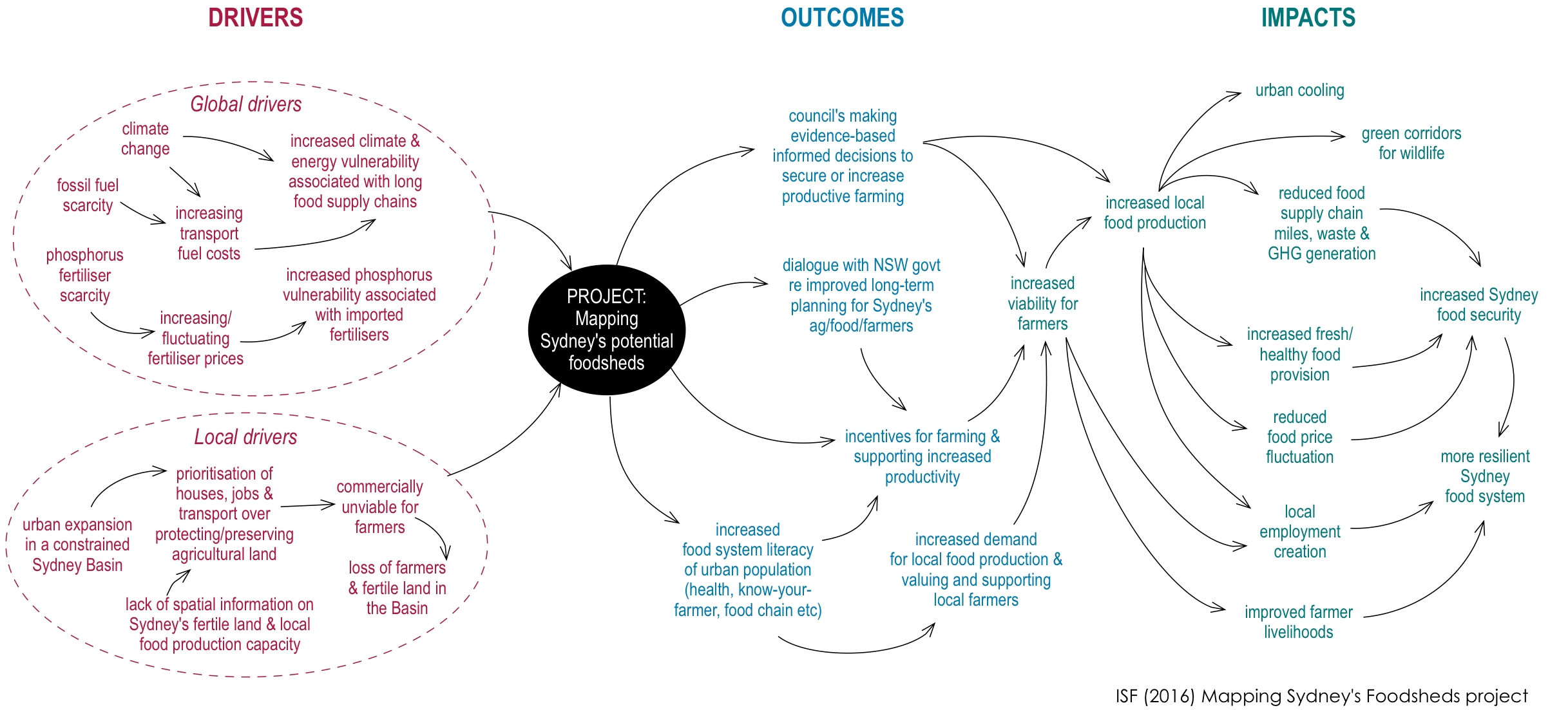
The food security of the Sydney Basin is under threat due to increasing reliance on distant production, distribution and transport systems, and increasing competition for land for housing in peri-urban areas. Few studies have been conducted about how Sydney will feed itself into the future – and what changes are needed to ensure Sydney remains food secure in decades to come.
A ‘foodsheds’ approach can inform an integrated, smart approach that will ultimately ensure Sydney is food secure and that farmer livelihoods and fertile soils are protected, while providing housing, jobs and mobility for a growing Sydney. Inspiration for this approach came from the U.S-based Foodprints & Foodsheds Project. The Victorian Eco-innovation Lab in conjunction with partners has also initiated a Foodprint Melbourne project.
The goal of the Mapping Sydney’s Foodsheds project is to increase the resilience of Sydney’s food system to both global and local challenges.
Project objectives are to:
- Develop, apply and map Sydney’s current and future foodsheds
- Identify and evaluate feasibility and desirability of potential future foodsheds in Sydney Basin through local stakeholder engagement
- Create an evidence base to support councils, state and federal decision making to stimulate and support agricultural productivity in the Sydney Basin
- Increase the food literacy of consumers, related to farming, supply chain and health.
Our food system is made up of a number of complex stages and interactions, from farms and laboratories to storage and transportation, processing plants, markets, supermarkets, and finally, consumers. Mapping our food production is a way of capturing the flow of food within this system, and by mapping various scenarios for future change, we can begin to understand where the system’s vulnerabilities lie.
This project has developed mapping to indicate where Sydney’s current and potential food producing areas are located. A range of scenarios were modelled and mapped to indicate how different situations – climate shocks, changes in diet and population growth, for example – will affect Sydney’s food security. You can see the interactive maps here.
Project partners:
- Research provider: Institute for Sustainable Futures, University of Technology Sydney
- Funders: Building Resilience to Climate Change: Local Government NSW and the Office of Environment & Heritage
- Lead proponent: Wollondilly Shire Council
- Reference Group:
- Sydney Peri-Urban Network (SPUN)
- NSW Department of Primary Industries (DPI)
- Regional Development Australia Sydney (RDA-Sydney)
- NSW Farmers
- Other partners: CSIRO Agriculture Flagship (Brad Ridoutt)
Project contacts:
- Laura Wynne Laura.Wynne@uts.edu.au
- Dr Dana Cordell Dana.Cordell@uts.edu.au
Disclaimer
The results of the research as published on this website do not purport to reflect the views of any of the Funding Partners and Project Partners. Any conclusions or recommendations are solely the result of the independent research undertaken by the Institute for Sustainable Futures at the University of Technology Sydney.
Whilst all due care and skill has been used in the research and development of the content of this website, the content is provided for information purposes only and use of the content is at the user’s own risk.
To the fullest extent permitted by law, UTS, the Funding Partners and Project Partners, disclaim all liability for any loss or injury arising out of, or related to, the use, inability to use, authorised use, performance, or non-performance of sites on this website however caused, including by negligence.