The study found that, in 2011, the Sydney Basin produced half a million tonnes of food – enough food to feed 20% of its population, including 40% of its demand for eggs, 10% of vegetables, 38% dairy, 55% meat and 2% of fruit. This is somewhat lower than Melbourne, which currently feeds 40% of its population with local fresh produce.
Future food production scenarios
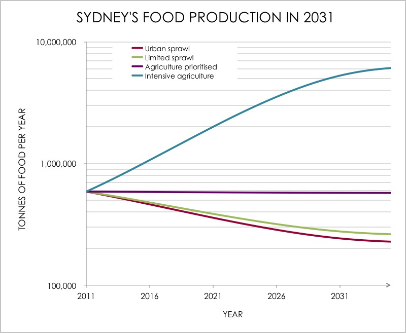
1. Urban Sprawl scenario: What if Sydney’s agriculture was not protected and the proposed population growth under the Metro Strategy occurred in an unconstrained way?
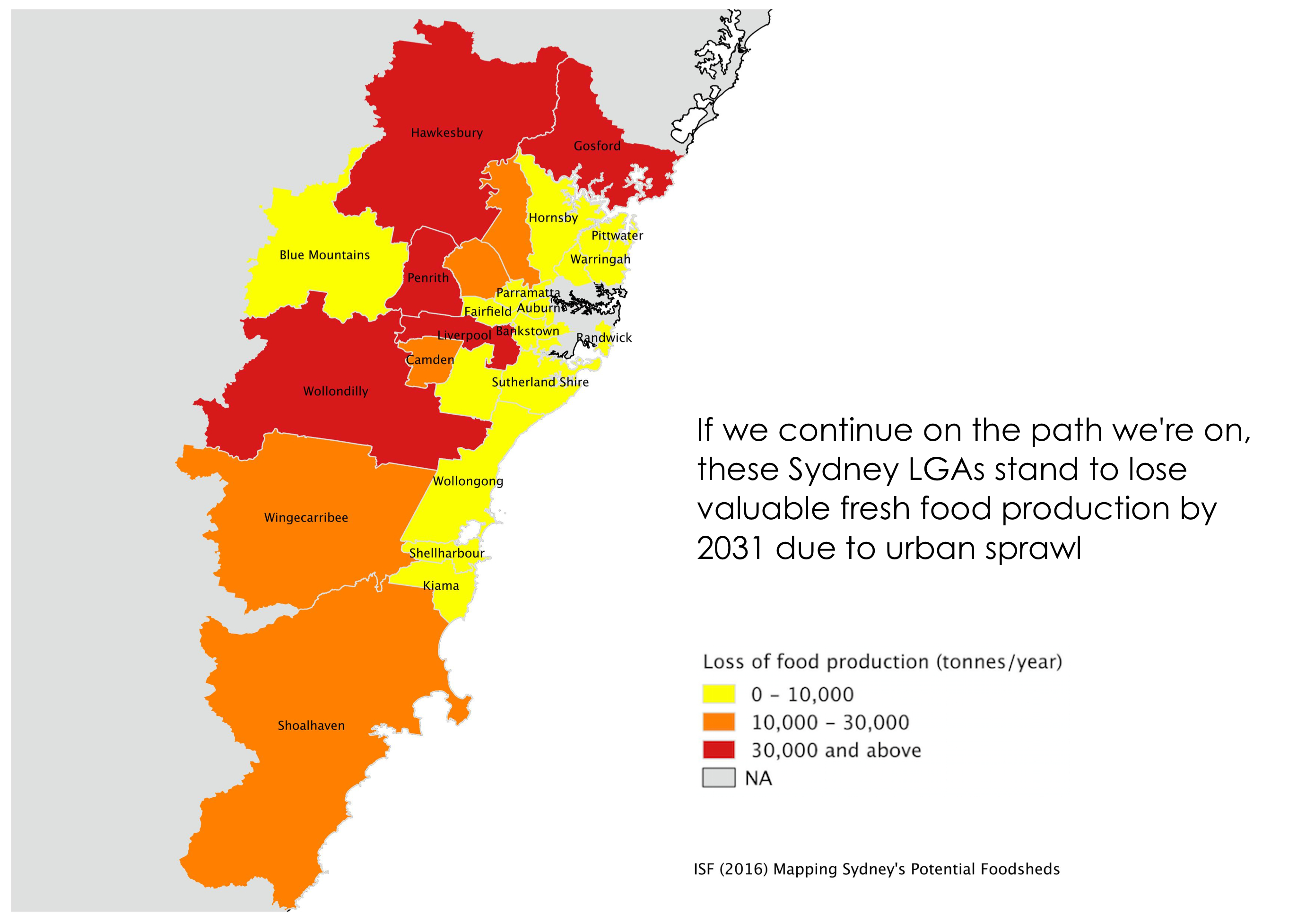
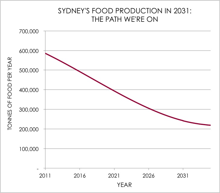
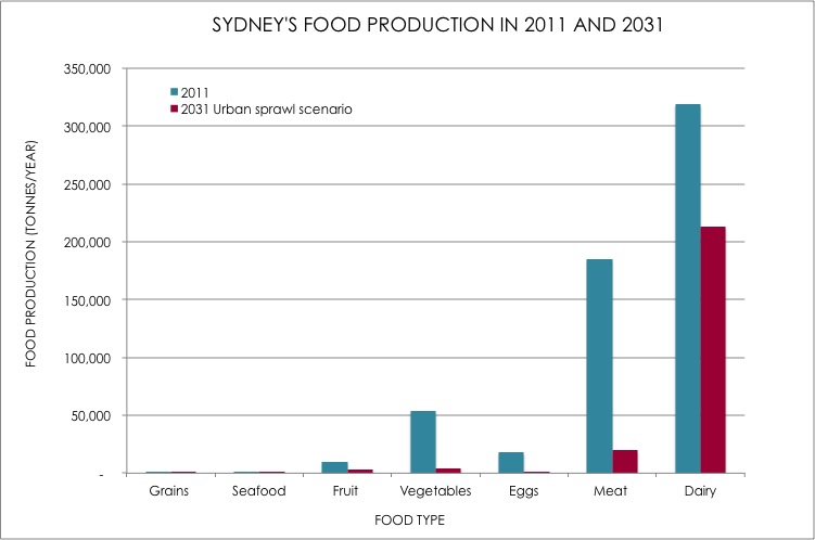
If we continue down the path we’re on, Sydney stands to lose approximately 60% of its total food production by 2031 (Figure 2). Vegetables, meat and eggs will be hardest hit: 92% of Sydney’s current fresh vegetable production could be lost, 91% of meat and 89% of eggs (Figure 3). This is because the current planning system tends not to prioritise agriculture as a land use, meaning urban sprawl into peri-urban areas is permitted. This scenario is based on Sydney’s metropolitan strategy, A Plan for Growing Sydney, which allocates new population growth to each local government area, and, concentrates urban growth around North West and South West Growth Centres. Consequently, loss of fresh food production is greatest in Wollondilly, Liverpool, Penrith and Hawkesbury areas.
As a consequence of this loss of agricultural land to urban expansion, coupled with 1.6 million extra mouths to feed, food production in the basin would only be able to feed 6% of Sydney instead of the current 20%, increasing Sydney’s vulnerability to a range of risks.
2. Limited Sprawl scenario: What if urban development occurred on existing urban land or lower priority agricultural land?
Somewhat surprisingly, this scenario does not result in much protection of Sydney’s agricultural land. That is, the loss of agricultural land is only marginally less than the urban sprawl scenario with no protection (figure 4). This is because there is no Class 1 agricultural land in the Sydney Basin, resulting in very little preservation of existing agricultural production, and hence losses are significant. This means Sydney will still face the same vulnerabilities as the Urban Sprawl scenario.
3. Agriculture Prioritised scenario: What if the proposed population growth under Metro Strategy occurred in a constrained way, such that current urban develop could intensify to high density, but not expand onto existing agricultural land?
This scenario essentially protects the current agricultural base, in terms of production. If we choose a pattern of urban development that involves densification – that is, utilizing the existing urban areas better, growing up instead of out, we could continue produce around half a million tonnes of food a year. Although importantly, as proportion of Sydney’s growing food demand, food production declines, to only meet 14% of Sydney’s demand. This raises the question of whether protecting the current agricultural base is therefore sufficient, or if we need to increase agricultural productivity too? Sydney is less resilient than Melbourne (and the national average) in terms of the proportion of the city population it can feed.
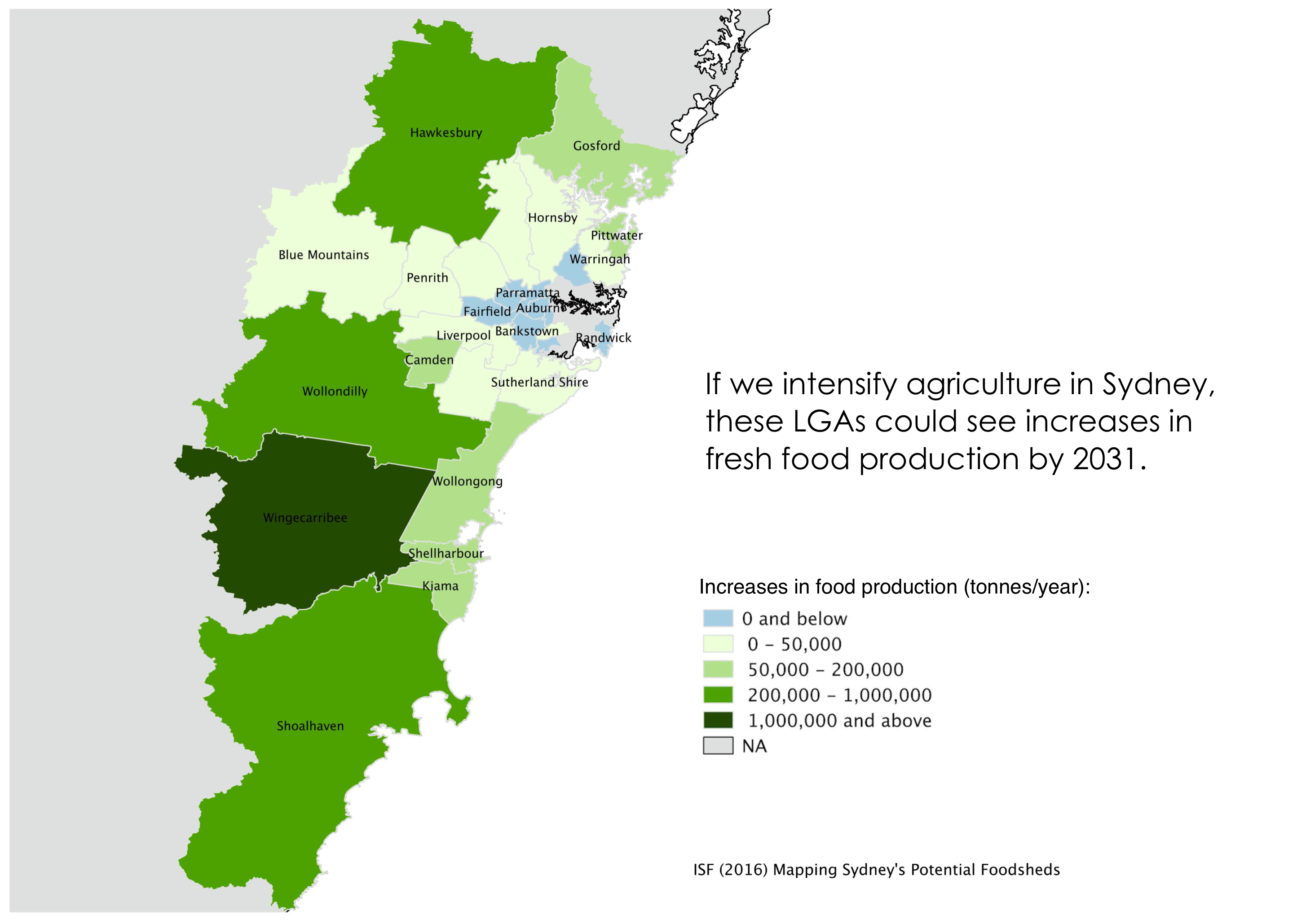
4. Intensive Agriculture scenario: Hypothetically, what if Sydney were to maximise agricultural production in terms of highest yields (tonnes of food per km2)?
In this scenario, existing farmland is essentially converted into agricultural production systems that maximise output, such as intensive horticulture (greenhouses), poultry sheds and feedlots. While this scenario ignores sustainability factors like environmental pollution, reduced urban amenity, animal welfare and sustainable diets, it does indicate that hypothetically Sydney could increase current food production from 580,000 tonnes per year eight-fold to 5,280,000 tonnes of food per year (figure 3). Indeed, Sydney could become an ‘exporter’ of vegetables, eggs and meat if agricultural productivity was maximised and protected. The hypothetical gains in this scenario are largely associated with converting graze lands in Wingecarribee to intensive livestock and vegetable production, and to a lesser extent intensifying agriculture in Hawkesbury and Shoalhaven local government areas.
Of course, not all of this land would be suitable for intensive agriculture, and many caveats apply to the plausibility and practicality of this scenario given risks related to profitability, capital investment and other matters such as biosecurity. This hypothetical scenario is only intended to provide an idea of the potential maximum food production that could be squeezed out of the land, and is not intended to indicate a desirable path for the future.
A pathway forward?
This project has modelled four wide-ranging future scenarios for food production (figure 4). While some of these scenarios appear extreme or unrealistic, they nonetheless demonstrate that the path we’re on – urban sprawl – needn’t be set in stone: we can and need to implement effective policies and strategies that seek to balance housing with food production, environmental protection and health. The next step will be to collaboratively identify and develop desirable and feasible pathways for sustainable agriculture in the Sydney basin together with key government, industry and community stakeholders.